
Location Analysis for Bus Stops in Hamburg with WebGIS GOAT
The Hamburg State Agency for Roads, Bridges and Waterways (LSBG) is tasked with systematically retrofitting approximately 2,400 bus stops for barrier-free access. The automated, standardized multi-criteria analysis required for this is being developed using the WebGIS GOAT.
General information
- Client
- Freie Hansestadt Hamburg
- Period
- 2025 -
Planning cases
- Multi-criteria site evaluation
- Automation of specialist procedures
- Stakeholder communication
Overview
The systematic prioritization and barrier-free retrofit of approximately 2,400 bus stops presents a massive planning and logistical challenge. Given limited resources, it’s crucial to initiate measures where they will have the greatest impact—both in terms of accessibility and cost-efficiency. To this end, the Hamburg State Agency for Roads, Bridges and Waterways (LSBG) is pursuing a fully digital, serial planning approach to ensure efficiency and scalability. The core challenge lies in the sheer number of individual stops and their complex evaluation criteria—from spatial integration into the urban fabric, to accessibility, to sociodemographic factors. Only a highly automated, data-driven, holistic approach can make this complexity manageable.
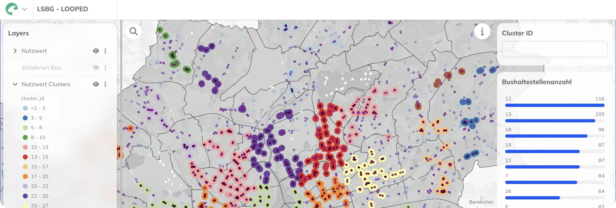
This is where Plan4Better comes in: a web-based solution for clustering prioritized sites, integrating all relevant data (e.g. timetables, sociodemographics and accessibility) and enabling a robust multi-criteria analysis—from initial preliminary planning to on-the-ground implementation within the LOOPED network. The solution is built on the WebGIS GOAT platform, which allows complex indicators to be calculated and visualized in a multi-stakeholder environment. The following GOAT components are being developed for the multi-criteria analysis:
-
Development of a dynamic workflow builder to combine and automate various analysis and data-processing steps
-
Expansion of GOAT’s toolbox with new analysis tools such as clustering (KMeans, Nearest Neighbors), regression analyses and custom formula calculations
-
Enhancement of GOAT’s dashboard functionality to provide the visualization modules required for the multi-criteria analysis
Worklows flowchart
Dashboard showing clustering result from analysis Workflows prototype Worklows flowchart
If you liked this, take a look at
FLEKS - High-resolution determination of minimum parking requirements for the City of Munich
The FLEKS project aims to develop a method that determines parking space needs based on urban planning, socio-demographic, and mobility-related parameters, and integrates it into an integrated mobility concept.
Read the referenceNeed an instrument built for your own question?
Book a slot and we will scope it against the decision you have to make.
Ready to make sense of your data?
Join planners, organizations and cities using GOAT to make better decisions, faster. No GIS expertise needed.